The Final Call |
National News
Winter’s frosty grip to tighten even more across portions U.S.
By AP | Last updated: Feb 26, 2015 - 10:01:23 AMWhat's your opinion on this article?

Heavy equipment works on a mound of snow that has been cleared from city streets at a "snow farm" in Boston, Feb. 16, New England remained bitterly cold Monday after the region's fourth winter storm in a month blew through.
|
Storms and freezing temperatures this past week in Tennessee caused 21 deaths, including 11 attributed to hypothermia. Gov. Bill Haslam elevated Tennessee Feb. 21 to a higher level state of emergency, meaning hard-hit areas may be eligible for state and federal assistance. Forecasters say the heavy precipitation has gone, but most of the state will see low temperatures in the teens to mid-20s the rest of the week. According to the Tennessee Emergency Management Agency, there are still slightly more than 44,000 power outages in the state.
Michigan is also heading back into the deep freeze, with temperatures plunging well into double digits below zero across most of the state early February 23. Cold temperatures and accompanying strong winds will make it dangerous to be outside. The National Weather Service predicts a return to the frigid cold that has gripped the state for much of the past week. That follows a lull February 22, when temperatures at 2 p.m. pushed as high as 30 degrees in the unincorporated Monroe County community of Lambertville, just north of Ohio. The weather service is forecasting overnight lows of minus 25 at Iron River in the western Upper Peninsula and minus 19 in Grayling and Mio in the northern Lower Peninsula.
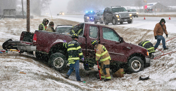
Frederick County, Va., Fire and Rescue Department first responders secure a pick up truck and administer aid to one of the occupants of the truck that slid off the snow covered southbound lanes of North Frederick Pike, just north of Winchester, Va., Feb. 16. Heavy snow and cold temperatures are making travel on roads hazardous.
|
The newest band of Arctic air could plunge parts of the Southeast and Mid-Atlantic into deep freezes that haven’t been felt since the mid-1990s, according to the National Weather Service.
The cold snap followed snow and ice storms earlier in the week of Feb. 20. The low temperatures caused much freezing and refreezing of snow, ice and roads. Weather forecasters warned that more sleet and freezing rain will be possible in the coming days.
Residents, meanwhile, prepared to deal with more school and event cancellations, power outages, and road hazards.
Temperatures dropping close to 0 degrees at home? That’s nothing to folks in Embarrass, Minnesota. On Feb. 19, the community reported a temperature of 41 below zero—without the wind-chill factor.
Forecasters say that’s the lowest recorded temperature in northern Minnesota this winter.
Elsewhere in Minnesota, it was 31 below zero in Ely and Fosston, and 28 below at Bemidji.
Bitter cold temperatures shattered decades-old records in many places—including Washington, Baltimore and New York.
The National Weather Service said the low Feb. 20 got down to 6 degrees at Reagan National Airport, just across the Potomac River from Washington. That beats the record low of 8 degrees, set in 1896.
At Baltimore’s airport, the temperature dipped down to 2 degrees. The record was 4 degrees, set in 1979.
In western Pennsylvania, temperatures dipped to minus 18 in New Castle, minus 15 in Butler and 6 below zero in Pittsburgh—all records.
At Newark Liberty International Airport in New Jersey it was 1 degree Feb. 20, beating the record of 5 set in 1936. Trenton’s temperature fell to zero and beat the low of 6 set in 1936.
In New York, a record was set in Central Park. The temperature at 7:01 a.m. Feb. 20 was 2 degrees. The previous record for the date was 7 degrees, set in 1950.
Delaware State Police say at least 16 children suffered minor injuries when three school buses they were riding were involved in a chain-reaction crash.
It happened about 4 p.m. Feb. 19 on Adams Road in Bridgeville. Troopers say three school buses were traveling north when the first bus slowed because of icy road conditions.
Officers say the third bus slid on the ice and rear-ended the second bus, which then hit the first bus.
Authorities say the buses were carrying 3rd- to 5th-grade students from the Woodbridge School District.
Police say at least 16 children were taken to area hospitals. The bus drivers were not hurt.
Troopers say no charges are expected to be filed.
With the National Weather Service forecasting higher temperatures, Chicago Public School students returned to class.
Chicago school officials announced schools would reopen Feb. 20 for the district’s nearly 400,000 students.
District officials ordered a cold-weather day for Thursday, Feb. 19, when temperatures stayed in the single digits. The wind made it feel like temperatures were double digits below zero. Numerous other school districts were also shut down.
The weather service forecasted high temperatures near 20 in northeastern Illinois, with wind chills near 15 to 25 degrees below zero in the morning. They also forecasted light snow, with little or no accumulation.
Another widespread round of ice, snow or freezing rain was predicted from Missouri to the Mid-Atlantic and as far south as Alabama and Georgia.
But even before the latest snowstorm, residents had to deal with school cancellations, power outages, road hazards and water main breaks from the punishing cold.
“Polar vortex” is so last year. Forecasters are calling the record-setting bout of icy air the “Siberian Express” because winds coming from Russia are traveling over the Arctic Circle and pushing into Canada and the United States.
“We can almost show the trajectory from Siberia all the way to the U.S.,” said a Weather Service official, noting meteorologists began using the term long ago.
Despite being the buzzword of winter 2014, polar vortex also has been used for decades in meteorology. It is a pocket of very cold air that typically swirls around the North Pole.
“Sometimes little pieces break off,” the official said. That has happened, meaning a frosty one-two punch.
Schools in Alabama sent students home early and NASA shut down its Huntsville facility as a storm began unloading ice, sleet and snow.
The weather service said roads were impassable in at least seven counties.
Dozens of school systems dismissed students early or canceled classes altogether. NASA closed early at its Marshall Space Flight Center because of deteriorating road conditions.
A Boston-bound commuter ferry carrying more than 100 passengers had trouble steering in the ice and had to be towed to port.
The ferry Massachusetts departed Hingham at about 8:30 a.m. Feb. 20 right behind an ice breaker, said Alison Nolan, an official with Boston Harbor Cruises. After the ferry went off course, the ice breaker towed it to Boston, arriving about 45 minutes later than normal. No one was hurt and the boat was not damaged.
The deep freeze transformed Niagara Falls into an icy spectacle, encasing the trees around it into crystal shells and drawing tourists who braved below-zero temperatures.
The Niagara River is flowing below the ice cover, so the falls aren’t completely frozen.
But days of subzero temperatures have created a thick coating of ice and snow on every surface near the falls, including railings, trees and boulders. The massive ice buildup has become a tourist magnet.
(Compiled from combined Associated Press reports.)

News Search
Loading
Follow The FinalCall.com Networks


Join The FinalCall.com e-List
 Click Here Stay Connected!
For Email Marketing you can trust
Farrakhan Articles
- Unmasking Mr. Dershowitz
- Activists charge environmental poisoning and ‘silent homicide’ in San Francisco
- President spews more incendiary rhetoric as election draws closer
- Covid-19 and the divine chastisement of Florida
- The National Guard was deployed in Atlanta, what does this mean as shootings, violence plague other American cities?
- Our babies are dying, where are our friends?
- Hurling truth at Falsehood Nation of Islam responds to lies of Atty. Alan Dershowitz
- The impact of a universal message
- Police traffic stops in nation’s capital disproportionately target Blacks
- A Call to Action’ to address Covid-19 in Black Chicago
INSIDE STORIES AND REVIEWS
-

-

About Harriett ... and the Negro Hollywood Road Show
By Rabiah Muhammad, Guest Columnist » Full Story -

Skepticism greets Jay-Z, NFL talk of inspiring change
By Bryan 18X Crawford and Richard B. Muhammad The Final Call Newspaper @TheFinalCall » Full Story -

The painful problem of Black girls and suicide
By Charlene Muhammad -National Correspondent- » Full Story -

-

-

-

Exploitation of Innocence - Report: Perceptions, policies hurting Black girls
By Charlene Muhammad -National Correspondent- » Full Story -

Big Ballin: Big ideas fuel a father’s Big Baller Brand and brash business sense
By Bryan Crawford -Contributing Writer- » Full Story -
